
An Inadvertent Fortress Moat
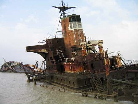
In 2004, the United Nations Development Programme (UNDP) published a report on the environmental hazards posed by over 280 sunken ships littering the 36-mile stretch of Iraq’s coastline along the northern end of the Persian Gulf. 3 wars later (the Iran–Iraq War from 1980 to 1988, the 1991 Gulf War, and the U.S. invasion of Iraq in 2003), a broken chain of tankers, tugs, barges, and patrol boats—"many of which still hold petroleum products, unexploded ordnance, and possibly rocket fuel, propellants, and toxic chemicals"—form hulking barricades in a poisoned sea stew sluicing around Iraq’s two and only deep-water ports, which are critical to receiving reconstruction supplies.

According to the UNDP survey, “Aside from the 282 sunken vessels identified in the UNDP survey, hundreds more remain submerged in the channels and estuaries north of Umm Qasr and near the neighbouring territorial waters of Kuwait.”

Leaking oil is the main culprit threatening the Gulf, where close to “80% of people in the region get their freshwater from desalination plants there”, according to this article. But with many of the shipwrecks containing live explosives, the half-submerged galleons are extremely dangerous to move, and in increased counter-clockwise water currents I imagine them swaying around almost like beached whales rolling in the surf, or sunken skyscrapers packed with bombs, “munitions, pesticides, refined fuels, and pollutants” that ooze out industrial chum galaxies from their great steel stomachs stinking of an ocean death. The last 25 years have turned the Iraqi portion of the Gulf into a disastrous toxic graveyard, spreading, territorializing - Occupation in the form of an informal coastal minefield; or, a perfect inadvertent fortress moat.
Asylum world brings us some Google map images of the submerged armada. (And thanks to Javier Arbona for dropping this my way.)
posted by Bryan Finoki • Permalink
![]()
![]()


0 Comments:
Post a Comment
<< Home